

A Landscape Photographer's Road Trip Through The Cairngorms (Part 1 of 2) Braemar's 1715 Commerative Stone, The Fraser Bridge of 1752 and the Cairngorm Mountains |
|
Setting The Scene - The natural stone boulder shown on the left, was sculptured and dated to commemorate the second Jacobite uprising of 1715 and is situated near to the place, where the Jacobite Rebellion banner was said to have been raised, by the Earl of Mar on the 6th of September 1715, to signify the start of hostilities and the second all out war against the Protestant British. But like all of the other Jacobite uprisings before this date and after (and there were many from the late 1600's through to the mid 1700's), it quickly turned into something of a catastrophe and was doomed right from the start, due to a lack of of good leadership, planning and logistics and which led to the untimely death of many thousands of young men on both sides of the conflict, from all across the entire Northern regions of the United Kingdom. But even as the Earl of Mar and the 800 heavily armed clansmen who surrounded him, raised the new Jacobite standard to proclaim, that James VIII (the Old Pretender) should be reinstated as the legitimate King of Scotland, an ornamental globe fell from the top of the flag staff and rolled across the grass in front of him. This caused immediate consternation and alarm, amongst the many clansmen who witnessed it and was seen to be a very bad omen indeed. As it recalled the time when a similar ceremonial globe from the top of King Charles I’s staff, had also fallen off and rolled across the courtroom floor in front of him, during his trial for treason and for which he was soon found guilty, with his own head then being chopped off and rolling around in the wicker basket it fell into. |
||||||||||||||||||
Here is a diary of events, starting from the second Jacobite uprising of 1715 and beyond:
|
|||||||||||||||||||
 |
|||||||||||||||||||
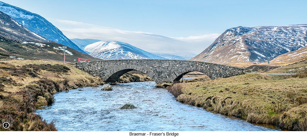
How to get there - From the Village of Braemar, head South out of the village following the Old Military road, now named as the A93 and follow it as it heads up into the mountains, with the River Dee winding its way up the centre of Glen Clunie to your right. Then after driving for a couple of miles up the hill, you will see the commutatively decorated boulder on the side of the road to your left, as shown in IMAGE 1 at the top of this page Street View, Map View. You will then come to a small parking area just a little further up the road on your right, so park here if there is space and walk back down to the boulder to take your shots, with the old military road forming a nice 'S' shape, that will help to lead the viewers eye all the way through the scene and on to the snow capped mountains in the distance. Then back in your vehicle, continue driving for a few more miles up the A93, until you reach the old Fraser's Bridge built in 1752, also on your right, Street View, Map View. If you look in the image above, you will see there is a red gate on the left side of the bridge, but this is only a snow gate and unless it is particularly snowy when you are here, it should be open and so you are allowed to drive over the bridge. So assuming the gate is open, drive over the bridge and park your vehicle in the space next to the cattle grid on your right and which I then chose to frame out of the shots shown in IMAGES 2 and 3. So having now parked next to the cattle grid and without blocking off the road, walk back over the bridge and then down the A93 for a hundred yards or so, before cutting down through the heather and on down to the edge of the River Dee, to take your shots of the scene shown ABOVE and to the RIGHT. |
|
||||||||||||||||||
|
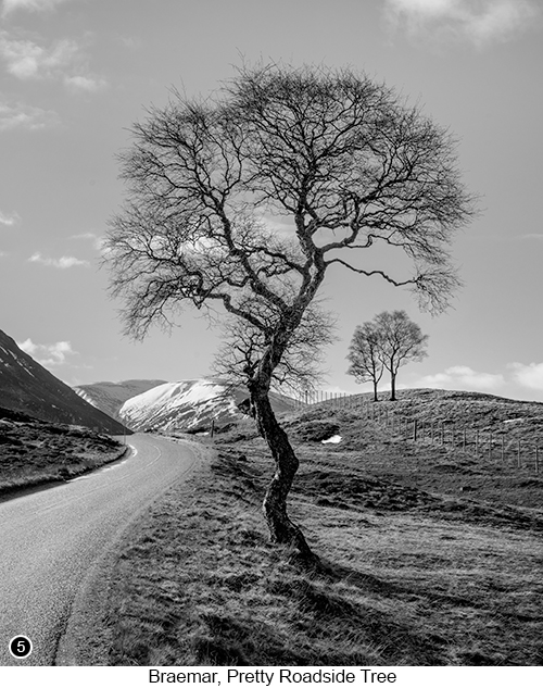
Then back in your vehicle, if you continue to drive further down the road on the other side of the bridge, for about another mile and a half, you will come to a long, old, dilapidated wooden barn structure, standing right at the side of the road. Assuming it is still standing when you are here of course and which I found to be very interesting photographically, as shown in IMAGE 4 to the left. This structure not only looks good set against the snow capped mountains in the background, but also has lots of close up and macro detailed opportunities within it, especially if you are a photographer who enjoys taking close up, grungy, monochrome shots, or broken windows surrounded by rotting wooden frames etc - which pretty much means all of us right? Having taken your shots of the 'Old Empty Barn', get back into your vehicle and retrace your steps, the way you came in and then back over the old stone bridge, to rejoin the main A93 and turn right, so you are now heading further up into the mountains. About another couple of miles further along the A93, as it continues to climb gently into the mountains and heading towards the ski resort at the top of the pass. You will eventually come to sweeping left hand bend, followed by a tighter right hand bend, with parking spaces over on your left and several trees over to your right, behind a wooden fence. You will also see a pretty little tree, with a trunk has been bent into an 'S' shape by the wind, standing right beside the main road, as shown in IMAGE 5, below. I think this is quite a simple yet very effective shot, that should be very easy for you to work with and a good subject, that will allow you to practice your compositional techniques. Because if we look at the shot below and take a minute to analyse it, |
||||||||||||||||||
| it is quite easy to see what I was trying to achieve when I framed up the shot, Street View, Map View.
So basically what I am alluding to here (even though I say this myself), is that I think this is a very successful photograph, both compositionally and artistically, but one that at the same time, should be relatively easy for you to capture. It can be taken whilst hand holding your camera, as you stand right alongside the edge of the road, but that at the same time, ticks nearly every one of those little compositional boxes, that we all like to tick in our work whenever we can. And is also going to be a subject, that should work at any time of year and in any type of weather, in both black and white and in colour. So what are you waiting for, grab your camera and go there now...! |
 |
||||||||||||||||||
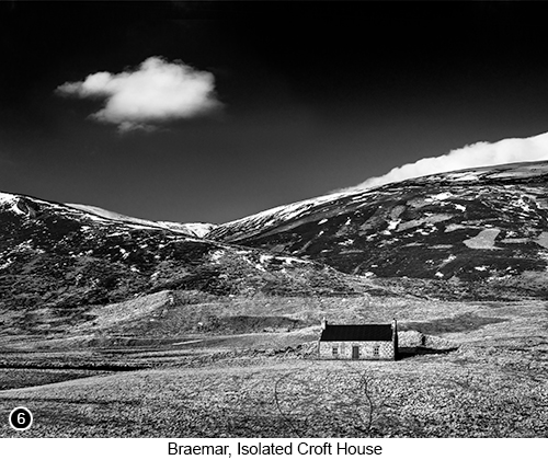 |
Having now taken your version of the shot shown above, go back to your vehicle and continue driving up into the mountains for another couple of miles, until you come to this next easy to shoot scene, of this cute little isolated old stone built croft house, that you will find stands in the bottom of the glen to your right, as shown in IMAGE 6 on the left, Street View, Map View. And that I was also able to line up and compose in such a way, that it too ticked as many of those little compositional boxes as I could make it tick. Yes folks, there can indeed be occasions in this weird and wonderful thing called landscape photography, when it is simply a matter of being there, getting out of your vehicle to cross a road, as you bring the camera up to your eye to hit the shutter release button and bingo, it's a wall-hanger shot. Admittedly, this doesn't seem to happen very often, but on this relatively short stretch of road, it happened to me twice here with the tree and the old croft house and then a couple of times more just a little further on up the hill and down the other side, which is amazing. OK, moving onto the next shot in this sequence, after capturing your version of the cute little croft house and the undulating hills behind it, as shown on the left and which I found to be more than a little reminiscent of the Ying and Yang symbol when I was shooting it.
Next return to your vehicle and continue to drive up the hill until you reach a large official car park on your left, about half a mile below the peak of the ridge and just before the ski resort and ski lift facilities, Street View, Map View. |
||||||||||||||||||
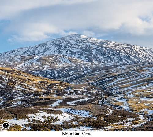
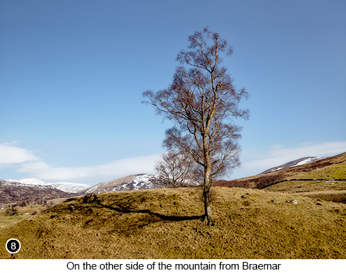
| I then got out of the car again and with no particular shot in mind, walked down to the furthest edge of the tarmac hand holding my camera. As I waited for a few moments for an area of diffused light to start spreading across the peak from the right and then lower down the side of the mountain and click, for yet another very satisfying image, as shown in IMAGE 7 on the right. OK, perhaps this shot on the right isn't so much of a contender for a portfolio grade image as the previous two, but none the less, still very satisfying to take and look at. We then continued to drive over the top of the mountain and down through the glen at the other side and further along the A93 for another few miles. Until I spotted another tree that I could isolate, against a snowy backdrop of rolling hills, as shown in IMAGE 9 below, Street View, Map View. You will find there is a smallish graveled area, directly at the side of the road near to this next location, where I was able to safely park my vehicle, away from the edge of the road. But it is not an official parking area and looks more like something the local farmer would use to load and unload his cattle, so be prepared to move out of the way if you are asked to do so. We then got back into our car and continued to head in the same direction for another 20 miles or so, as we tried to find a large spectacular waterfall called 'Reekie Linn' on the River Isla, that we had read about online. So we wrote down the postcode that the web site said would lead us to it and then put this into our satnav, to help us pinpoint the location of the falls. And what a huge mistake that was, as it led us off in completely the wrong direction. But like the complete idiot that I obviously am, I continued to follow the satnav's directions, even as it sent us past the front of a farmers house, then through the farm yard and even as we started to bounce our way, down a very narrow and deeply rutted muddy track, that can only ever have been used for tractors and farming machinery - yes I know, how stupid could I be to not realise what was happening? Well stupid enough to continue following what the lady in the dashboard was telling me to do it seems and to keep on driving straight ahead for the next mile or so, until we finally sunk into an axle deep ditch in the middle of nowhere. |
 |
||||||||||||||||||
 |
But luckily, I seem to be quite a capable driver, that doesn't go into panic mode at the drop of a hat. Even though my dear wife does enjoy a good panic and who was now flipping between moments, of wailing such helpful comments as "We're DOOMED!!!!" and then spitting feathers at the satnav lady and wanting to punch her in the face. Hell hath no fury like a women misdirected into a mud bath using Satnav it seems. However, I managed to keep a cool head, as I started to gently rock the car backwards and then forwards, by screaming the engine and spinning the wheels in first gear, before quickly slipping it into reverse and gunning the engine, then back into first again etc. I kept doing this (mainly because there was very little else I could do), until the car began to slew around within its own space, with thick orange and brown mud, spraying up high all around us and onto the windscreen. This forward and backwards motion, continued on for a little while longer, until I somehow managed to get the vehicle pointing back in the direction that we came in. So as I tried to tune out the white noise now assailing my left ear, I kept going with this rocking backwards and forwards motion, by flipping quickly between first and reverse gears. Until I was lucky enough for the front right tyre to momentarily catch onto a large patch of meadow grass and twigs, that were hanging down into the right side of the mud bath. Which miraculously gripped for a second and helped to launch us back up into a forward motion and out of the deepest part of the sludge, phew. So having now managed to negotiate my way out of the worst part of the quagmire from hell, I kept the revs going and dropped it into second gear, then third, until I had built up enough speed, to allow me to fishtail and aquaplane our way back out onto the main road. Where by the time the rubber hit the tarmac, we were both hanging white knuckled onto the roof handles and panic laughing like a pair of demented hyenas. |
||||||||||||||||||
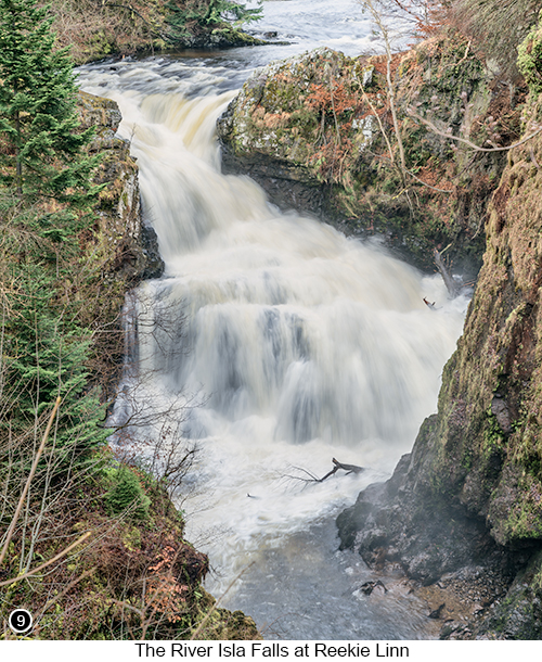
We continued to drive around looking for the Craigisla Bridge over the River Isla, and the Reekie Linn car park, which sits at the side of the Craigisla Bridge, until we eventually located it here, Street View, Map View. Now when we were at the Reekie Linn Falls, it was just after a major 100 mph storms had blown through the week before and so lots of the larger old trees surrounding the falls, had either been uprooted completely, or snapped in half like twigs and so all this carnage meant there wasn't going to be much chance for any worthwhile photography. So the shot your see here on the right in IMAGE 9, is more of a record shot than anything else. But I did want to show you the potential of this place for the future, when I am sure the area around the falls will be tidied up and the damaged trees removed. But none the less, even though it wasn't so good for photography when we were there, I think it is still a really worthwhile waterfall to visit, just to look at the sheer size of it and the amount of water that noisily gushes over it. If you look at the centre right of the shot, you will see the upper part of a tree sticking up out of the water. Then a little further down the falls, you will see where another branch is sticking out of the water. These are both parts of the same full grown tree, so should give you a good sense of how big these falls really are. Tip: All the images shown throughout this chapter, were taken during what I am going to call the 'Scottish Highlands Spring Run Off'. The term 'Spring Run Off' is something I heard to describe the period between late winter and early spring in Canada and North America. Where after the winter snows begin to melt and flow down from the Rockies, all the rivers and waterfalls become swollen and therefore really good for photography. We even spent a few weeks in Canada several years ago at this exact time, just to photograph this phenomenon, which was amazing. But it isn't something that normally happens in the UK, as our winters are not cold enough or snowy enough to create these conditions. However, in the Cairngorms and especially around Braemar, we do get a sort of mini version of the 'Spring Run Off', so that is when I timed our visit to be here, so I could see it and more importantly photograph it. So if you would like to photograph some easily accessible mountains, with the outlines of the melting snow, contrasted across the colour of the heathland down its sides (see image 7). Or you like to photograph lots of gushing waterfalls and overflowing rivers (see image 2), then I would advise that you choose to visit this region in late winter or very early spring. Because to my mind, this is always going to be the best time of year to be here with your camera. I am also fairly confident, that even in summer after a good, long, downpour, there will never be as much water in the rivers and falls as you will find in the spring run off. Also, the mountains without their snow capped peaks in summer, just wouldn't look quite so tall or as interesting in my humble opinion. |
 |
||||||||||||||||||
--Exif information for each of the numbered shots shown throughout this chapter --1 - Canon EF16-35/2.8L USM, 1/160th Sec, f/16, ISO 250, Focal Length 35mm, taken on 2nd Mar at 10:22 --3 - Canon EF24-105mm f/4L IS USM, 1/250th Sec, f/16, ISO 250, Focal Length 28mm, taken on 1st Mar at 10:22 --4 - Canon EF24-105mm f/4L IS USM, 1/250th Sec, f/16, ISO 100, Focal Length 28mm, taken on 27th Feb at 12:28 --5 - Canon EF24-105mm f/4L IS USM, 1/160th Sec, f/16, ISO 100, Focal Length 35mm, taken on 1st Mar at 10:05 --7 - Canon EF24-105mm f/4L IS USM, 1/250th Sec, cropped, f/11, ISO 100, Focal Length 28mm, taken on 27th Feb at 10:17 --8 - Canon EF24-105mm f/4L IS USM, 1/125th Sec, f/16, ISO 100, Focal Length 45mm, taken on 27th Feb at 11:32 --9 - Canon EF24-105mm f/4L IS USM, 1/6th Sec, f/16, ISO 100, Focal Length 80mm, taken on 28th Feb at 11:16 |
|||||||||||||||||||
Continued in Part 2 of 2, A Landscape Photographer's Road trip Through The Cairngorms |
|||||||||||||||||||
If you have enjoyed reading these 'Extra' chapters to my Guide Book and think you might also enjoy reading 79 more chapters across 270 pages, that also includes more than 340 Fine Art quality images, along with detailed descriptions and large scale maps to guide you to the exact location of where I took each and every one of them and which then goes onto discuss the techniques and tools I used to process them, but where everything is written in plain easy to understand English? Then please consider buying the Book. |
|