Invermoriston and the River Moriston Falls - Part 1 of 2 Featuring a Bridge built in 1813 by Thomas Telford that crosses over the River Moriston Falls and where Salmon leap in Autumn |
|
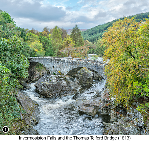
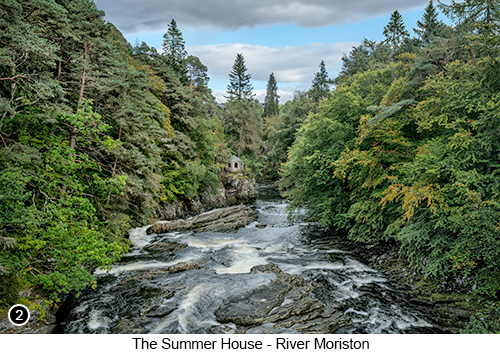
Setting The Scene - The old bridge at Invermoriston was built by Thomas Telford as part of a much larger road and bridge building scheme across Scotland, that aimed to finally and fully open up the Highlands and Islands to ‘Grand Tour’ visitors and businesses alike and which ultimately led to the creation of nearly one thousand miles of new roads, with over 120 stone bridges and which earned Thomas Telford the local tongue-in-cheek nickname of ‘The Colossus of Roads’. The old bridge that crosses over the River Moriston Falls as shown here on the left in image ONE, was built in 1813 and originally formed part of the only carriage accessible route between Drumnadrochit and Fort Augustus, until it was eventually superceded in the 1930s by a much wider concrete bridge and is where you can now stand to take your shots of the old bridge and the River Moriston Falls. The River Moriston and the River Moriston Falls, are easy to find being situated only a couple of miles from the head of Loch Ness on the main A82 road and is where you will also find the tiny village of Invermoriston with its scattering of houses supported by a couple of shops and a restaurant. The name “Invermoriston” is derived from adding the Gaelic word of “Inver” meaning the mouth of a river, to the name of the village, so as this village is situated at the mouth of the River Moriston, it is called Invermoriston. There is also an old Summer House that sits beside the River Moriston on the opposite side to the old bridge from the new bridge, as shown in image TWO below and which was constructed as a Folly during the Victorian era by the Laird of Glenmoriston. He had the Summer House built here perched right on the edge of the lower part of the falls, so he could then impress his house guests, by having their afternoon tea served to them as they watched the wild salmon, leaping their way upstream to their spawning grounds during the annual autumn migration. There are also plenty of enjoyable walks and hikes around Invermoriston, with the most scenic being the one that goes all the way up to the top of the hill that sits directly behind the village (called Sròn Na Muic, which translates from Gaelic as "The Nose of the Pig"), which starts in the village, as shown here in this Hikers Guide for the area. |
There is also an online Guide to lots of other areas of interest in the Glen Moriston area, written in the 70's by a local amateur historian and which can be viewed Here. How to get there - Invermoriston Falls - Street View 1, Street View 2 - Map View. Driving down the A887 from Glen Moriston and the Inverwick Forest area (covered in the book on page 221 Chapter 70), you will drive along for 20 miles or so with the River Moriston on your right, until you reach an odd shaped 'T' junction at Invermoriston (where the A887 joins the A82 at a tight curved bend, as shown here), with a sign for Fort William to your right and Inverness to your left, turn right here. You will then see a large official car park on your immediate left as you turn right on this junction, so turn into the car park and park wherever you can. Then grab your gear (a wide angle lens seems to work best for this location I find) and walk out of the car park and turn left towards the bridge, which you should now see just a couple of hundred yards in front of you. From the centre of the new bridge, but standing to the right side of the road, you will then see where I shot the scene of the River Moriston Falls and the old bridge in Autumn, as show in image ONE above and if you then cross straight over the road on the new bridge, you will then see where I shot the scene of the Victorian Summer House perched on the edge of the lower falls, as shown in image TWO on the right. By way of a quick tip, when shooting from the new bridge and especially if you are using a tripod, then try to wait for a reasonably sized gap in any traffic, so that the vibration caused by the weight of any passing vehicles, doesn't blur your shots. |
|
|
--Exif information for each of the numbered shots shown throughout this chapter --1 - Canon EF16-35/2.8L USM, 1/10th Sec with -/+2 stop bracket, f/16, ISO 50, Focal Length 16mm, taken on 5th Oct at 16:05 |
|
If you have enjoyed reading these 'Extra' chapters to my Guide Book and think you might also enjoy reading 79 more chapters across 270 pages, that also includes more than 340 Fine Art quality images, along with detailed descriptions and large scale maps to guide you to the exact location of where I took each and every one of them and which then goes onto discuss the techniques and tools I used to process them, but where everything is written in plain easy to understand English? Then please consider buying the Book. |
|