Loch Maree and the Peak of Slioch - Part 2 |
Loch Maree is around 14 miles long at its longest point and 2.5 miles at its widest and is said to be the fourth largest loch in the whole of Scotland. Loch Maree also contains five large islands and over 60 smaller islands created during the last ice age and which are mostly covered by trees. However the trees that do grow on these islands are quite important, as they represent a small but still significant remnant of the greater Caledonian forests that use cover all of Scotland and are of the ancient and now quite rare Caledonian Pinewood variety and which first started to grow here over 10,000 years ago, as they began to colonise the land straight after the last ice age and which have continued to remain untouched by the hand of man ever since. The landscape around Loch Maree is both wild and rugged, as well as being surrounded by many low lying mountains (which are collectively referred to as Corbetts if they are under 3,000 feet tall) and of course Slioch which is classed as a Munro being a mountain that is over 3,000 feet tall. Loch Maree is also a good area for hill walkers and mountaineers, kayakers, fishermen, photographers and wild life watchers, with the largest concentration in the UK of Black Throated Divers (a species of bird) that can often be seen here, as well as wild Deer, Otters, Red Squirrels and Pine Martens etc., and there are even 12 separate species of dragon fly that inhabit this area, some of which grow to the size of a small bird such as a Robin. |
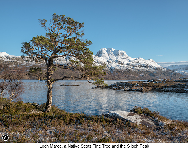 |
How to get there - the second area I am now going to discuss and where I took several of the photos shown on this page, is a few miles back further South around Loch Maree, but is going to be a little more tricky to describe, as there is no path that leads to where I took SHOTS 5, 6 and 7 and also the terrain I walked over to get into position for these shots, I later found out is in fact quite dangerous terrain to walk over, even though it looks perfectly fine from the road and is why I was so willing to wander across it to get these shots, being so blissfully unaware of what I was actually doing (which is a good example of both being a 'Man Thing' and a 'Photographer Thing' - Doh!!). So instead of giving you a step by step guide to where I was actually standing to take these shots, I am only going to give you the general idea of the area where I was and leave everything else up to you, so that it then becomes your choice as to whether you choose to scout out this area for your own photographs or not, because I do not feel it would be appropriate or safe for me to guide you to this exact location, in fact it would be quite the reverse - as explained below! So heading back South around Loch Maree from the picnic location described previously in part 1 of this chapter, first drive out of the parking area and back onto the A832 by turning left and then driving South for around five miles, as you head back towards the way you first came into the Loch Maree area. You will then pass a second large official parking area on your left Street View - Map View and which you need to drive past, as you then pass over the brow of a small hill before coming to an open view of Loch Maree and the Slioch Peak on your left and with several Scots Pine standing alone near to the shore. But if you did go into this second car park and drive down the left hand side of it, you will see there are a couple of faded warning signs that warn of Hidden Crevasses all around this area and how you should not leave the car park.!!! |
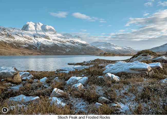 |
Why these warning signs are there and why they are advising you not to leave the car park? Imagine if you were standing on the shores of Loch Maree around 11,000 years ago, you wouldn't actually be standing where you are at all, but instead you would be standing at almost a mile higher elevation on the top of an ice flow, because that is how deep the glaciers became as they passed through this area of Scotland. Now if you can also imagine that back then, the mountains that these glaciers were grinding over and around, were also several thousand feet taller than they are today. So the fact the mountains are now several thousand feet smaller than they used to be only a relatively short time ago, is due to the action of these glaciers on the mountains as they either pushed over or around them and which broke off many thousands of large truck sized chunks of the mountains as they passed through, to then carry these huge chunks of rock down towards the sea. But then when the glaciers suddenly started to melt away quickly around 10,000 years ago, these large chunks of rock began to melt out of the ice flow and deposit themselves across the entire upper part of the glen. So to get a mental picture of what I am trying to describe to you here, think of a large elongated dish shape structure in the earth that has been gouged out by the sheer weight of a mile thick glacier, that then became evenly backfilled with huge irregular shaped boulders and where a lot of those boulders were deposited standing vertically and with deep narrow gaps between them. Then add in 10,000 years of moss, grass and heather growing on top of these boulders, where the soil these plants were helping to create, has then been blown around by the wind to fall loosely in between the gaps to fill them in, but only with enough soil to support the weight of a thin flat layer of vegetation that now grows across the tops of these boulders and which is continually being hollowed out again, by the flow of fresh rainwater as it flows around the base of the boulders. |
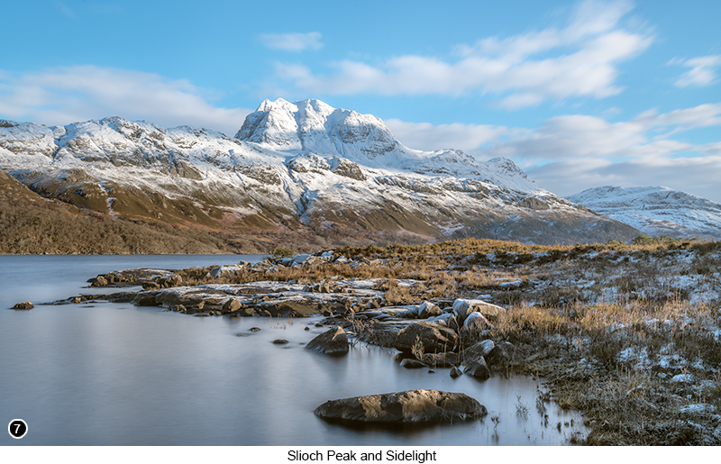 |
I then continued down the hill and further South along the A832, until I came to a short graveled driveway on my left Street View - Map View, but which had a steel barrier stopping vehicular access along it for more than about 15 feet and is where I then walked along this track for about 30 yards, until I could get around a small hill on the left of the track, so that I could then setup my camera for a multi shot pano of the whole scene, as shown below in SHOT 8. The multi frame pano shot below, also shows you an example of the local in-filled terrain, with the upper tips of some of the glacial moraine boulders as discussed above, still peaking up through the grass and the heather and what looks like an easy to walk across meadow, but which it probably most definitely isn't. |
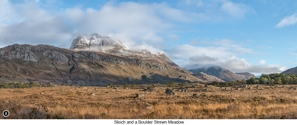 |
--Exif information for each of the numbered shots shown throughout this chapter --5 - Canon EF16-35 f/2.8L USM, 1/30th Sec, f/16, ISO 50, Focal Length 26mm, taken on 4th Jan at 11:55 --7 - Canon EF16-35 f/2.8L USM, 30 Sec with 10 stop ND, f/16, ISO 100, Focal Length 32mm, taken on 4th Jan at 13:04 --8 - Canon EF70-200/2.8L IS USM, 1/160th Sec, f/16 (7 shot vertical orientation pano), ISO 250, Focal Length 70mm, taken on 3rd Dec at 13:19 |
If you have enjoyed reading these 'Extra' chapters to my Guide Book and think you might also enjoy reading 79 more chapters across 270 pages, that also includes more than 340 Fine Art quality images, along with detailed descriptions and large scale maps to guide you to the exact location of where I took each and every one of them and which then goes onto discuss the techniques and tools I used to process them, but where everything is written in plain easy to understand English? Then please consider buying the Book. |
|