Sutherland and the North, North Western regions of Scotland - Part 2 of 4 Wild, remote, rugged and windswept, but most importantly of all, breathtakingly beautiful and quite rarely photographed |
 |
Kylesku Bridge, or "Drochaid a' Chaolais Chumhaing" as it is known in Scottish Gaelic, is a modern box girder bridge, set in the North West of Sutherland, that crosses over the narrows of Loch a' Chàirn Bhàin. Construction for the bridge started in August of 1981 and is said to have cost just over £4 million on completion, even though the original budget was set at only £2.7 million in 1978, when the original plans and proposals were first being drawn up. The bridge was then constructed relatively quickly within a three year period, by first building up both of the large twin 'V' shaped support legs, on opposite sides of the Loch at its narrowest point, then bringing in the large 640 tonne single central span of the bridge and setting it on top of the two main support legs. The main curved central span of the bridge, having already been constructed at another nearby site and then floated around to this part of the coast on several large barges. It is also said, that within the bridge's original design brief, that it should be capable of withstanding wind speeds well in excess of 100 miles per hour, and for sustained periods of time - which believe me, having been up here on holiday during a cyclonic storm event, where the wind speeds kept buffeting up to and possibly above that 100mph limit (see part 4 of this Sutherland chapter for proof), it needed to be. The bridge was then formally opened to public traffic in July of 1984 and then later formally opened by Queen Elizabeth II, on August the 8th 1984.
|
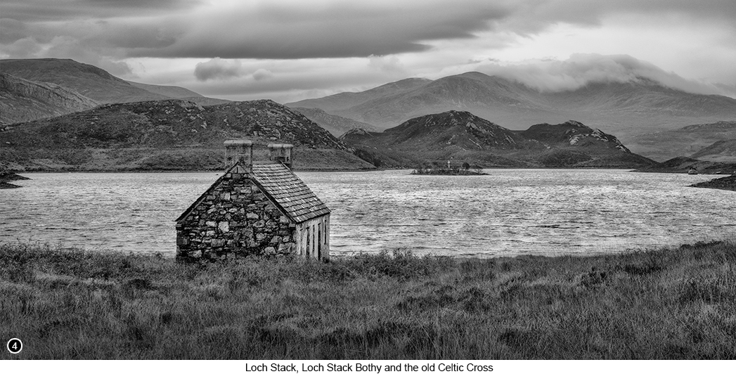
This area of Loch Stack (now part of Sutherland), is known to have once been the main province of the Clan Macleod of Assynt in the very early 1500's and so this Celtic Cross (see Shot 4 Below), may have been placed here by one the Macleod chief's, to commemorate some significant event or person in their clan's history. Such as when in the mid 1500's, this area fell under the tyrannical control of a Macleod leader, who became known to the local population, as “Huistean Dubh nan tuagh”, which roughly translates from Scottish Gaelic as "Black Hugh of the Axe". Now Black Hugh of the Axe, was not a very nice person it seems (I mean who'd have thought with a nickname like that?) and who is said to have done many terrible things throughout his life, including terrorising and murdering many people across the North West of Scotland, including the outer isles. But who later in his life, developed a great dread of his own passing and then having to suffer through his own judgment day under the eyes of God and his fear of finally being held responsible for all the evil things that he'd done and the scores of people, he had chopped into pieces with his infamous axe. As I climb up the moor on the face of the hill, Sweet is the song of the birds from the glade How lovely the garment of mountain and field, Alone and sad-hearted I sit near this peak,
|
 |
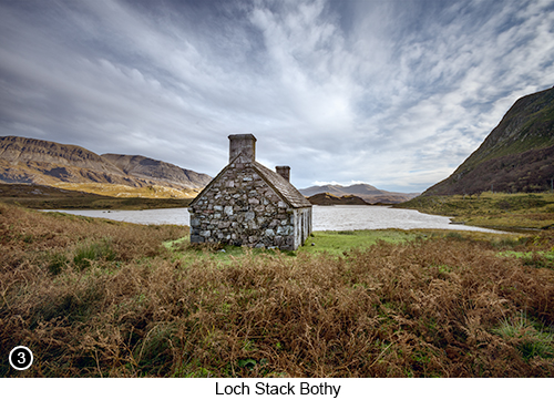
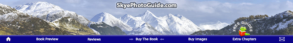
How to get there - Continuing on from Part 1 of this chapter, head back to the Inverkirkaig turn off as previously discussed - Street View, Map View, but this time instead of going straight back towards the Stac Pol viewpoint where you came in, turn left and head up the hill. Now continue driving on for mile after mile of yet more amazing scenery, until you reach the small fishing town of Lochinver - Street View, Map View, and where you will then rejoin the main A837 road heading further North. Then continue along the A837 until you reach a turn off to your left, that is signposted for the Kylesku Coastal Route - Street View, Map View. You are now on a scenic coastal route, that will eventually lead you to a 'T' junction with the A894 - Street View, Map View. Now turn left and continue on down the A894 for a little way further, until you cross over the very photogenic Kylesku Bridge. You will then see there is a large official parking area on your left, so pull in here and park wherever you can, for great views of the bridge and the surrounding mountains - Street View, Map View. The Kylesku Bridge and the wide rolling vista of mountain scenery that surrounds it, as shown in SHOT1 at the top of this page, is very photogenic indeed and will look good in pretty much any type of weather and at all times of year. I chose to get in close with my wide angle lens, to show you the sweep of the bridge and how it arcs neatly across from the lower left compositional third, up to and then beyond the upper right compositional third. But if you do not like the view from here, then there is another vantage point that many photographers also enjoy shooting of this bridge, and can be found by clambering up the rocky bank on the opposite side of the road from the car park and then shooting the bridge from up there. Then, once you have finished photographing the Kylesku Bridge and the surrounding scenery, get back into your vehicle and continue driving North on the A894 for another 12 miles, as you now head towards the Laxford Bridge area and the Laxford Bridge 'T' junction. But before you do reach the Laxford Bridge turn off, you will pass by a disused layby on your left, Street View, Map View (which might actually be a remnant of the old road and not a disused layby at all). Which even though it this layby/road is pretty well grown over, it is still none the less a great place to park up and take pictures, of the angular peak of Ben Stack directly in front of you, as shown in SHOT 2 above. When we were at this rarely photographed viewpoint of Ben Stack, the weather was pretty awful, with heavy rain and blustery winds (but believe when I tell you it got worse over the next few days, much worse..), but we were both really enjoying watching the mist and low cloud hitting the right side of the peak and then being pushed around it, in continuous waves of rolling mist. So we decided that as it was near enough to cup of tea and chocolate biscuit time (which seems to happen about every two hours or so throughout the day), we would make a brew and wait it out, to see if anything happened that was worth photographing and low and behold it did. After about ten minutes of sitting there taking in the scenery, I could see way off in the distance to my right that for whatever reason, a singular medium sized blue hole had been ripped open in part of the cloud base by the wind. It wasn't a very big hole and it was moving really fast, but more importantly for me, I could see that it was rapidly heading towards the peak of Ben Stack. So hot tea quickly gulped down and biscuit munched, I jumped out of the car, setup my kit on the tripod in the lee of the tailgate of the car, broke out my trusty old golfing umbrella and waited for the blue hole to arrive over Ben Stack, which it duly did. I then managed to shoot off a couple of dozen 'quick fire' shots in rapid fire mode, before the blue hole continued on its journey past the peak to my left and the peak once again fell back into the gloom. But what the heck, I was happy, because I knew I had grabbed the shot of it that I wanted. |
|
|
|
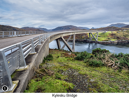
So having now shot the angular peak of Ben Stack within its surrounding landscape, get back into your vehicle and continue driving further up and along the A894 for another 3 miles or so, until you reach the Laxford Bridge area 'T' junction, Street View, Map View. With a sign for the A838 road heading off to your right, that will then lead you towards the tiny village of Lairg a few miles further on and take this right hand turn. Now continue driving down the A838 for another 3 miles or so. as you pass through yet more pleasant and very photogenic scenery and then on passed the back of the Ben Stack Peak now on your right. Until you eventually reach the Lock Stack Bothy viewpoint and the small official parking area over on your left and park here, Street View, Map View, for the viewpoint as shown here in SHOT 3 on the left Now I don't know how being in this place will effect you emotionally, but I find that whenever I am standing here looking down the glen at the 'Old Bothy', which is a scene that probably hasn't changed in any noticeable way over the last several hundred years, it really does seem to stir up something deep within me, that feels both generationally and ancestrally ancient. But that just might be me and due to some connection I now feel to my great grandfather, who was born in Scotland and came from the Clan Haig - which means that maybe I have some connection to the Haig Wiskey distilling family fortune. However none of it ever got passed my way unfortunately and oddly enough, even though I now live in Scotland on the Isle of Skye and have done so for the last 11 years (as of 2023), I really do not like the taste of Wiskey and never have. So it's never going to be a wee dram for me I am afraid..! |
After parking in the official Loch Stack Bothy parking area and looking out across the view as shown above and below, don't just jump out of your vehicle and begin striding out across the heather and bracken towards the old bothy to get your shots. As the ground all around the rear of the Bothy is very boggy, deeply rutted and covered in tall sedge grass and is also probably crawling with deer ticks. But instead walk down the road a little way further and onto a rough track that leads to the Bothy from the side of the road. Once there you can then back yourself up into the grass and heather a little way, to frame your shots using the wild grass as your foreground interest. I am only telling you this, because the first time we were here, I did exactly that and strode straight out into the grassy area directly to the left of the car park, as I couldn't wait to get down to the Bothy and start shooting. But then ended up struggling to negotiate my way down to it, without disappearing knee deep in the bog that sits behind it. Yet when I had finally struggled to get to within about a 30 feet of it and the socks on both my feet were beginning to feel squelchy and wet in my boots, my wife cheerily called out to me from the side of the Bothy and asked how I was doing in the bog, after she had walked down the road and discovered there was a track to it, but which neither of us could see from the car park - ho hum..! |
|
 |
|
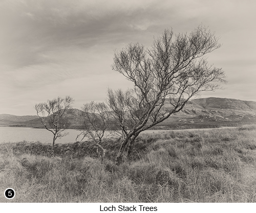
You will find there are lots of photo opportunities in this area and the Bothy can be shot from many different angles, both wide and zoomed in, as well as offering stitched panoramic opportunities as shown in SHOT 4 above. Unfortunately there is the road on the right side of the glen, but which is easily framed out, unless you are shooting really wide. Also there are some very interesting lighter coloured rock structures, that continue along the background to your front left. But unfortunately (for photography at least) there is a large mansion type dwelling almost directly behind you at this viewpoint, which to my eye would have totally ruined the shot for me and the feeling of age that I wanted to capture, so I concentrated on taking all my shots of the Bothy, looking down through the Glen towards the small island with the cross on it - which you should just be about able to see, at the back of the shot shown above. You will also see if you walk down the road a little way further past the Bothy, that over on your left there are several groups of straggly trees at the side of the loch, that look really great in winter without their foliage, as shown in SHOT 5 below right. I think the reason I took this shot and worked it in this monochromatic way, that both made it look old and film like, is because before we traveled up here on this occasion, I had recently been watching an old film about Faye Godwin from 1986 on youtube (a landscape Photographer who shot medium format film in the 70's and 80's). Faye was very well known in her time and highly acclaimed for her work in this area of Scotland and which obviously must have influenced how I went about making this shot. But unfortunately even though I intended to put a direct link in here, to the film I had recently enjoyed watching about Faye's work, for some reason it has since been removed? Tips and general observations - The light and the weather conditions in this Glen can be problematic, depending on the time of year you are shooting here. Because in winter, the sun rises up from the bottom of the glen as you look down it, but most of the time it is still hidden behind lower parts of Ben Stack to your right. And even though it does eventually get high enough above Ben Stack, to shine directly into the left of the Glen, as well as onto the roof of the Bothy, it does not do it for long. But on the very shortest days of the year, the sun never even rises above Ben Stack at all, when viewed from where you are now standing. |
|
So any side light that does appear on the Bothy in winter, is often going to be quite a fleeting thing to see. So you need to be prepared and be here taking your shots around midday, when the sun will then be at its highest and to give you the best chance of getting any usable side light. However in summer, the whole glen does get flooded with light for most of the day. But also in summer, this glen will become flooded with clouds of hungry Scottish midges, all fighting for a drop of your blood, unless there is a breeze over 6mph of course and then they can't fly, or attack you in their hordes. Yet oddly enough, I find the best light for shooting in this steep sided glen, is when it is fairly bright, but still quite overcast and moody. This way the shadows are less likely to block up so easily, as well as the highlights blowing out, especially if there is snow on the tops of the distant mountains. However, this glen is also usually quite windy and seems to act like a large funnel, that is constantly channeling even the mildest of breezes, into something a bit more gusty than it is outside of the glen. So if the light levels are low and the wind levels are high, as it probably will be when you are here, then you are going to need to use a much higher ISO than you are normally comfortable with, especially if you want to stop the grasses and branches of any trees moving etc. But this is not such a major issue these days, what with all those high capacity, high dynamic range sensored cameras that are now available. In other words, this is a glen that you are probably not going to be breaking out your 10 stop ND filter and using it to flatten out any ripples in the loch, unless you are very, very lucky. And instead you are probably going to be doing all of your shooting at shutter speeds around 160th of second or higher. Which I have found is about the bare minimum shutter speed I can get away with, if I want to stop things moving around too much. Of course you could throw on your 10 stop and go for a more ethereal look, or hope that it does indeed give you lots of sharp details, using the 'Long Exposure, Sharp Detail Effect' as and described in part 1 of my 4 part tour around Sutherland and the North, North West of Scotland. |
 |
| Another good tip that I can give you for this scene of the Bothy, shown in SHOTS 3 and 4 above, is that when you are here, you will soon see that all the Bothy windows have been boarded up. Which most of the time wouldn't be the end of the world and could even give the building more character. But unfortunately in this instance, they have all been boarded up with modern grey unappealing chipboard, which really doesn't look very good at all, but which I bet you could not tell from looking at the images above. So what I did to fool you (and yes I did it on purpose), was to find the perfect angle where I could shoot the Bothy, so that you can see there are windows in it, by allowing you to see the outline of the frames, but with nothing of what is within the frames showing. This way I knew the average viewer will assume they are either still normal windows, that probably look old, dusty and unkempt with lots of hanging cobwebs. Or that they have indeed been boarded up, but with some nice old weathered planks of wood, with knotholes and gaps between them or something. Either way, by hiding this unsightly detail from you, I made you subconsciously fill in those details for yourself without realising it, rather than ruining the romance of the shot, by showing you they are covered with chipboard and are no where near as good to look at, as you or I would like them to be. | |
Exif information for each of the numbered shots shown throughout this chapter --1 - Canon EF16-35/2.8L USM, 1/50th Sec, f/16, ISO 100, Focal Length 16mm, taken on 8th Nov at 12:39 --3 - Canon EF16-35/2.8L USM, 1/120th Sec, f/16, ISO 250, Focal Length 17mm, taken on 8th Nov at 11:30 --4 - Canon EF24-105mm f/4L IS USM, 1/200th Sec (7 shot vertical pano), f/16, ISO 400, Focal Length 60mm, taken on 7th Nov at 12:30 --5 - Canon EF16-35/2.8L USM, 1/160th Sec, f/16, ISO 200, Focal Length 16mm, taken on 8th Nov at 10:55 |
|
If you have enjoyed reading these 'Extra' chapters to my Guide Book and think you might also enjoy reading 79 more chapters across 270 pages, that also includes more than 340 Fine Art quality images, along with detailed descriptions and large scale maps to guide you to the exact location of where I took each and every one of them and which then goes onto discuss the techniques and tools I used to process them, but where everything is written in plain easy to understand English? Then please consider buying the Book. |
|